Our Great Streets Plan calls for all streets in Providence to be safe, clean, healthy, inclusive, and vibrant. We are building a network of “urban trails,” streets where you can still drive a car, but where walking and biking are the focus. Our urban trail network will ensure that our community members and visitors are free to choose how they get around. We call this network Via Providence.
Via Providence
In 2020 and 2021, we worked with community stakeholders, Providence-based brand strategist Margie Butler, and Boston-based wayfinding signage experts Roll Barresi to determine (1) how people will navigate the growing network and (2) what the network would be called.
Signage to Open Up Our City
As more of our urban trail network is built, we will install new signs to help people get around. Via Providence will feature:
- Wayfinding signs with arrows pointing to nearby destinations like parks, schools, business areas, libraries, and cultural institutions, with estimated travel times;
- Trailblazers featuring the Via Providence logo as a quiet reminder that one is traveling on the network;
- Orientation signs with big maps telling visitors where they are and helping locals see where they are going and;
- Interpretive signs highlighting stories about our diverse neighborhoods, cultures, and people.
Pathways Around Our City
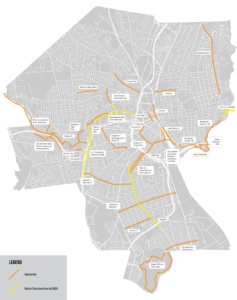
New streets have been upgraded to be part of Via Providence in recent years, and there are still more connections to make! Travelers can already get from Johnston to Olneyville along the Woonasquatucket River Greenway, from the East Bay to Fox Point and Downtown Providence along the East Bay Bike Path, and soon, will be able to get from Roger Williams Park to Downtown Providence, all via Via Providence. Below is a map of existing urban trails and those that will be finished soon:


