


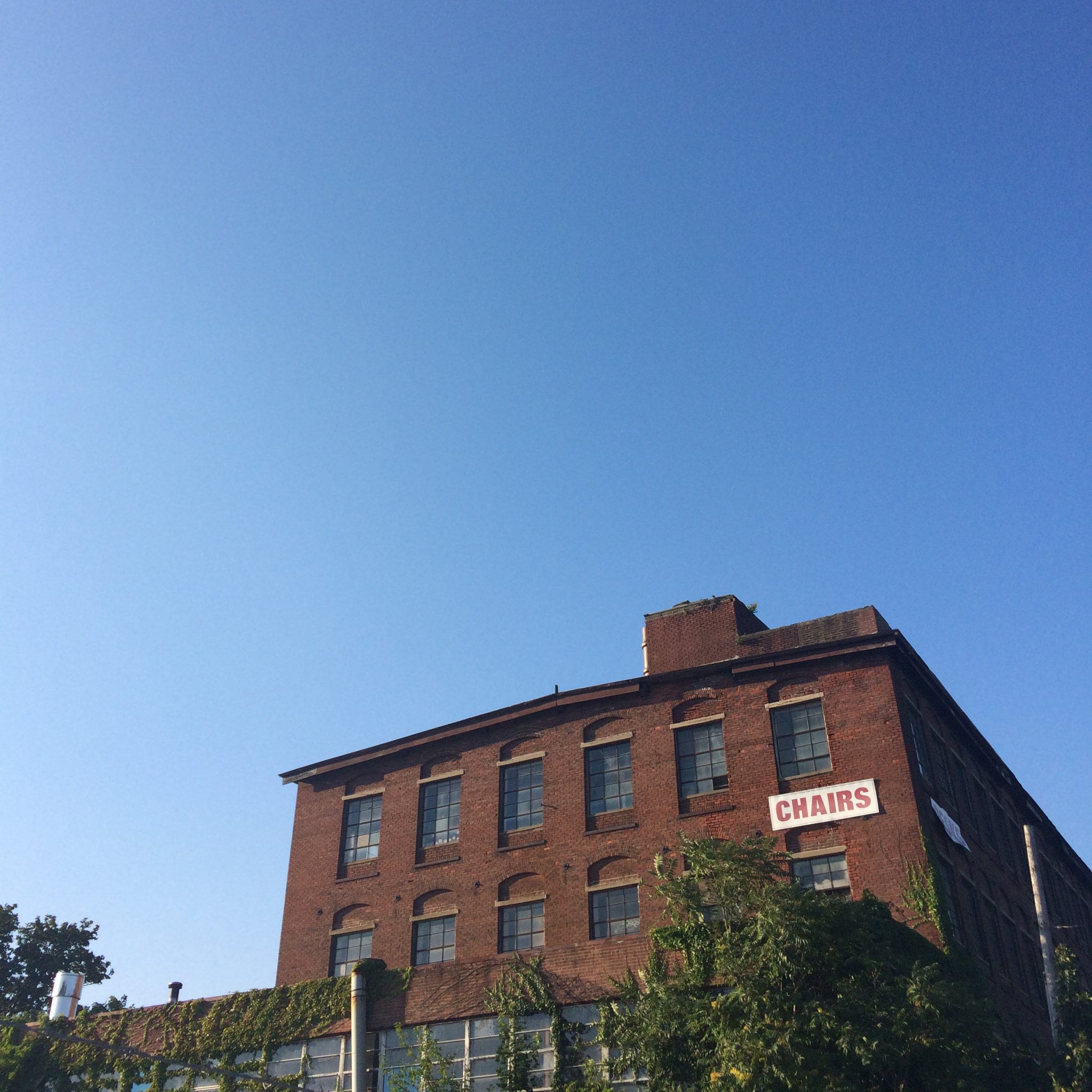


Image credits: Woonasquatucket River Watershed Council, Steel Yard @thesteelyard, The Wurks @thewurks
Woonasquatucket River Greenway Improvement Project
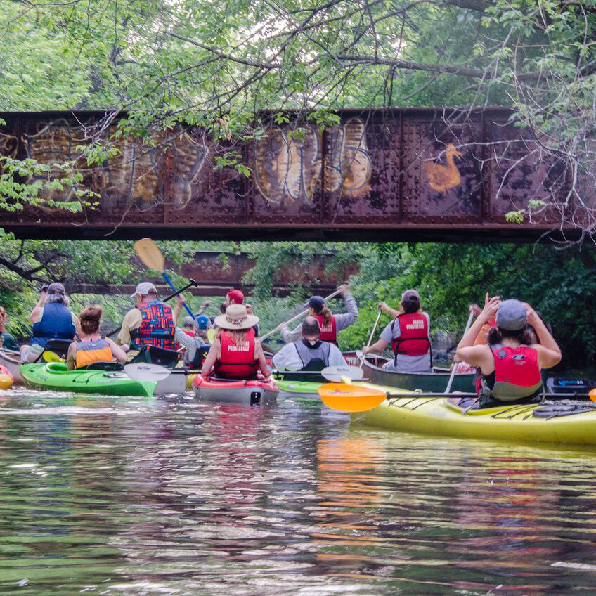
The Woonasquatucket River Greenway Improvement Project will enhance a one-mile section of the Woonasquatucket River Greenway between Downtown and Eagle Street in the City’s Valley and Smith Hill neighborhoods. In addition to being a key focus of the Woonasquatucket Vision Plan and Woonasquatucket River Watershed Council, this project is a critical segment of the citywide Urban Trail Initiative. This one-mile off-road, shared use path will provide a safe connection for those walking and riding bicycles between downtown Providence and Eagle Square, enhance the urban/natural river interface, increase public recreational use of the riverfront, strengthen stormwater management, encourage economic development, and create stronger connections between Downtown and the Smith Hill, Valley, and Olneyville neighborhoods.
With more than $10 million in funding for design, engineering, and construction from the the RI State Transportation Improvement Program, the Providence Capital Improvement Program, RI DEM and the Southeast New England Program (SNEP), the City began initial public outreach and analysis of alternatives in Spring 2019.
The project will break ground in March 2024. The Department of Planning and Development will host an informational meeting on March 19, 2024 at 5:30pm at the Farm Fresh Rhode Island Hub, 10 Sims Avenue in Providence.
The general construction schedule includes:
- March 18-22, 2024: Detour signs are installed and site preparations begin
- March 25, 2024: Signal timing modifications made to support detour routes
- March 26, 2024: Detour is implemented
- April-October 2024: Construction of all project roadway elements takes place
- Fall 2024-Spring 2025: Eagle Street kayak launch constructed
Construction will generally occur between the hours of 7am and 3pm Monday-Friday.
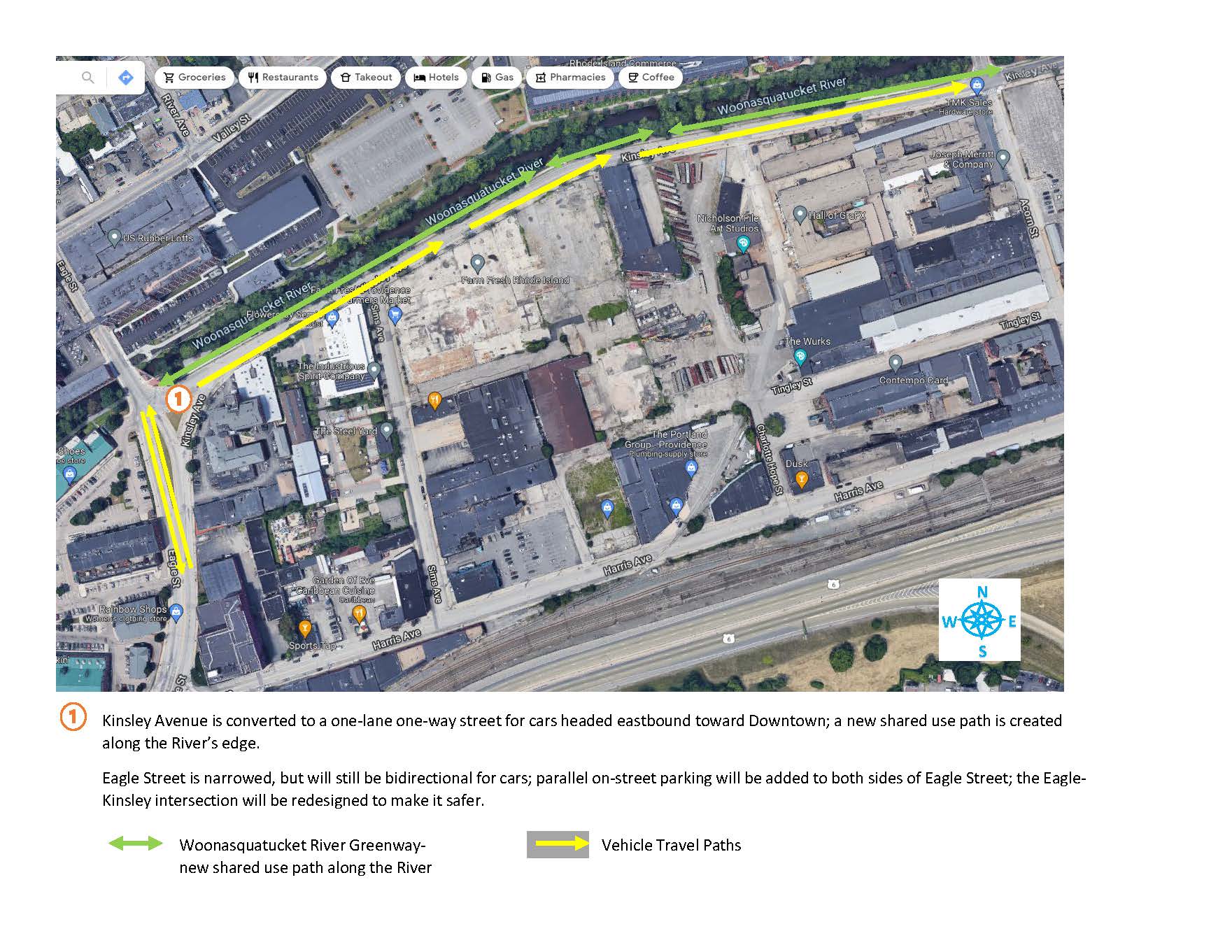
Kinsley Avenue will be converted to a one-lane one-way street for cars headed eastbound toward Downtown; a new shared use path is created along the River’s edge.
Eagle Street will be narrowed, but still bidirectional for cars; parallel on-street parking will be added to both sides of Eagle Street; the Eagle-Kinsley intersection will be redesigned to make it safer.
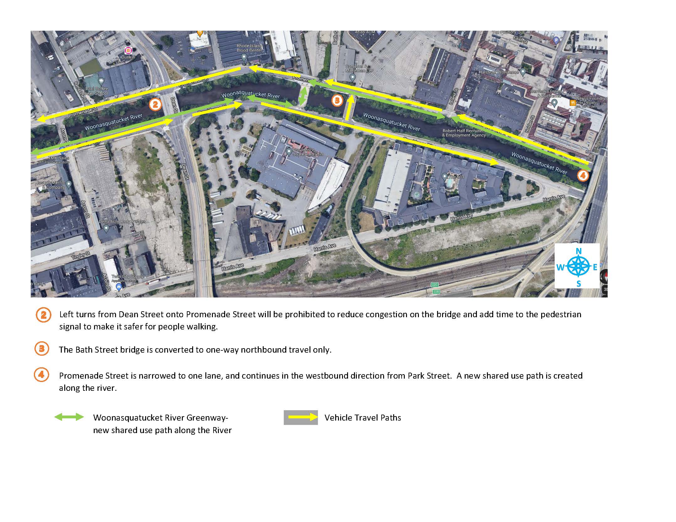
Left turns from Dean Street onto Promenade Street will be prohibited to reduce congestion on the bridge and add time to the pedestrian signal to make it safer for people walking.
The Bath Street bridge will be converted to one-way northbound travel only.
Promenade Street will narrowed to one lane, and continues in the westbound direction from Park Street. A new shared use path will be constructed along the river, separated from vehicular travel with landscaping, bioswales and other green infrastructure to enhance stormwater management and water quality while reducing flooding.
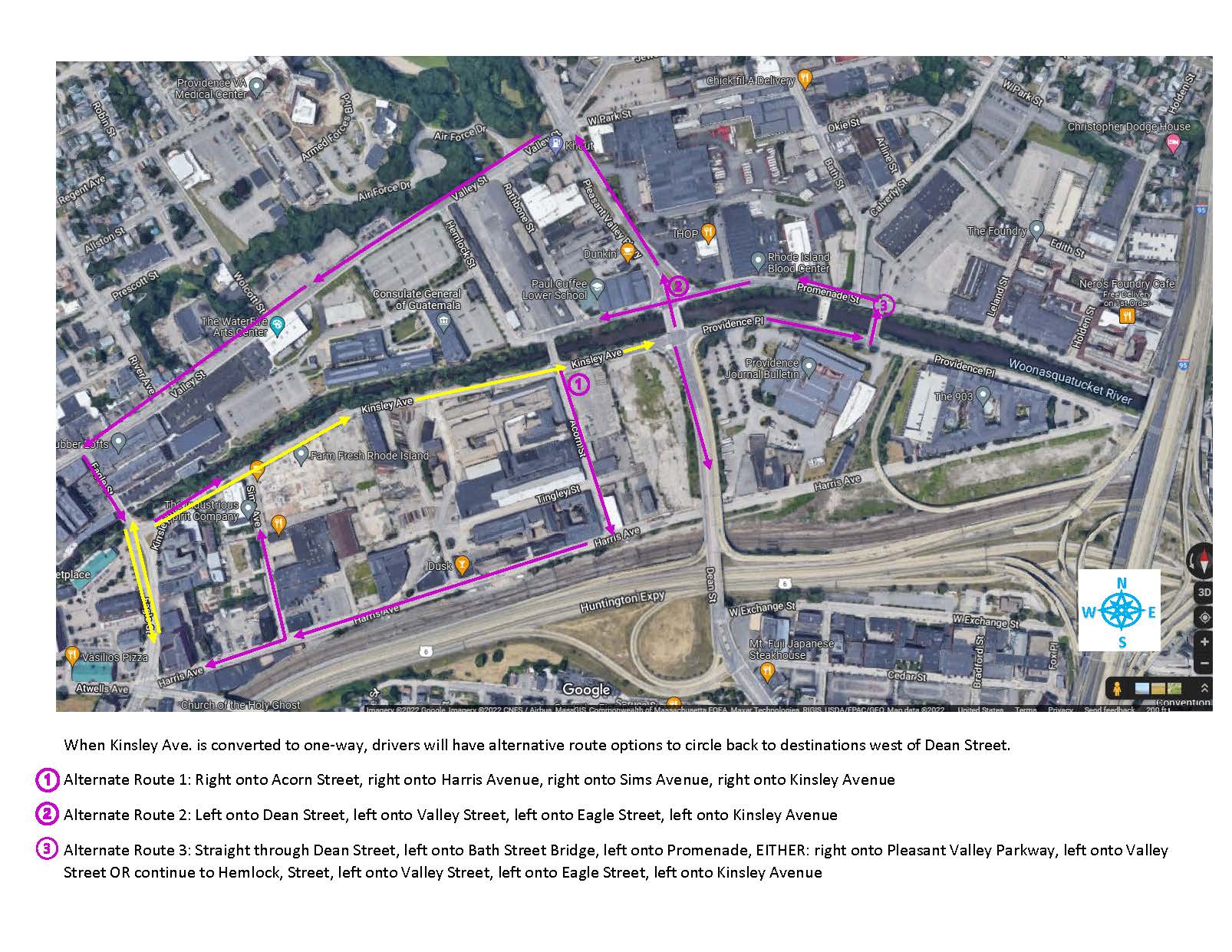
When Kinsley Ave. is converted to one-way, drivers will have alternative route options to circle back to destinations west of Dean Street.
- Alternate Route 1: Right onto Acorn Street, right onto Harris Avenue, right onto Sims Avenue, right onto Kinsley Avenue
- Alternate Route 2: Left onto Dean Street, left onto Valley Street, left onto Eagle Street, left onto Kinsley Avenue
- Alternate Route 3: Straight through Dean Street, left onto Bath Street Bridge, left onto Promenade, EITHER: right onto Pleasant Valley Parkway, left onto Valley Street OR continue to Hemlock, Street, left onto Valley Street, left onto Eagle Street, left onto Kinsley Avenue
Project Documents
-
- Woonasquatucket River Greenway Improvement Project Construction Update March 19, 2024 presentation
- Woonasquatucket River Greenway Improvement Project May 28, 2020, presentation in English and in Spanish
- Live Recording of the May 28, 2020 Public Meeting
- Questions and Answers from the May 28, 2020 Public Meeting
- Woonasquatucket River Greenway Draft Concept Plans January 22, 2020
- Woonasquatucket River Greenway Improvement Project June 17, 2019, presentation in English and in Spanish
- Woonasquatucket River Greenway Concept Sketch June 17, 2019
- Woonasquatucket River Greenway Improvement Project boards
Investigation Notices and Reports
In accordance with the Rhode Island Department of Environmental Management’s (RIDEM’s) Rules and Regulations for the Investigation and Remediation of Hazardous Material Releases (the Remediation Regulations), the City of Providence Department of Planning and Development is providing notice to abutters of their intent to conduct a Site Investigation along the Woonasquatucket River Greenway Corridor, from Providence Place Mall to Eagle Street along Promenade Street, Providence Place, and Kinsley Avenue. The goal of this investigation is to determine if a release of hazardous materials has occurred on the property. The investigation will involve the sampling of environmental media (specifically soil, sediment and groundwater) by Civil & Environmental Consultants personnel. The work is being conducted entirely in the public right-of-way along Promenade Street, Providence Place, and Kinsley Avenue.
The investigation is scheduled to be conducted in December 2019 and is expected to take approximately two weeks. The results of the investigation should be available by the end of December 2019.
For more information regarding this notice or this investigation, or with questions regarding the project, contact Jess Lance at (401) 680-8519. Project documents and additional investigation information can be viewed below or at the Woonasquatucket River Watershed Council offices located at 45 Eagle Street, Providence, RI 02909.
Site Investigation Notice Package-Woonasquatucket River Greenway
Additional Documents will be posted here as they become available.
Woonasquatucket Brownfields Assessment Program
The City of Providence has been awarded a Brownfields Assessment Grant by the U.S. Environmental Protection Agency (EPA) to conduct assessment and planning work related to the cleanup of brownfield sites throughout the Woonasquatucket River Corridor. The grant provides funding for Hazardous Materials and Petroleum-related Phase I and Phase II Environmental Site Assessments, Quality Assurance Project Plans, and Remedial Action Work Plans for sites within the Corridor. The intent of this work is to encourage cleanup of brownfield sites and make costs associated with redevelopment of brownfield sites more predictable. Brownfields are “properties, the expansion, redevelopment, or reuse of which may be complicated by the presence or potential presence of a hazardous substance, pollutant, or contaminant” (US EPA). If you are looking to buy, sell, expand, or refinance a business, or plan to develop a vacant, underutilized industrial, commercial, or mixed-use property in the Woonasquatucket River Corridor, this program is here for you!
PROGRAM OBJECTIVES AND BENEFITS
-
-
-
- Assist developers and property owners with due diligence measures and estimates of liabilities
- Engage community members regarding economic development priorities
- Improve the quality of life for residents
- Return blighted and contaminated properties to productive use
- Help property owners avoid potential government environmental enforcement actions or penalties
- Build community pride
- Promote economic development, provide jobs, and support businesses
- Create safer, healthier places to live, work, and play
-
-
Click here for the Woonasquatucket Brownfields Assessment Program Brochure.
Click here for the Woonasquatucket Brownfields Assessment Program Brochure (Spanish).
IS MY PROPERTY ELIGIBLE?
Site eligibility is based on a number of factors, and we encourage you to talk with our brownfields team about your property.
For more information about the program, eligibility of your property, or to discuss your vision for brownfields within the Corridor, please contact:
David Everett
Principal Planner
City of Providence Department of Planning and Development
444 Westminster Street
Providence, RI 02903
401-680-8400
E-Mail: deverett@providenceri.gov
Though this project has been funded, wholly or in part, by EPA, the contents of this webpage do not necessarily reflect the views and policies of EPA.
![]()
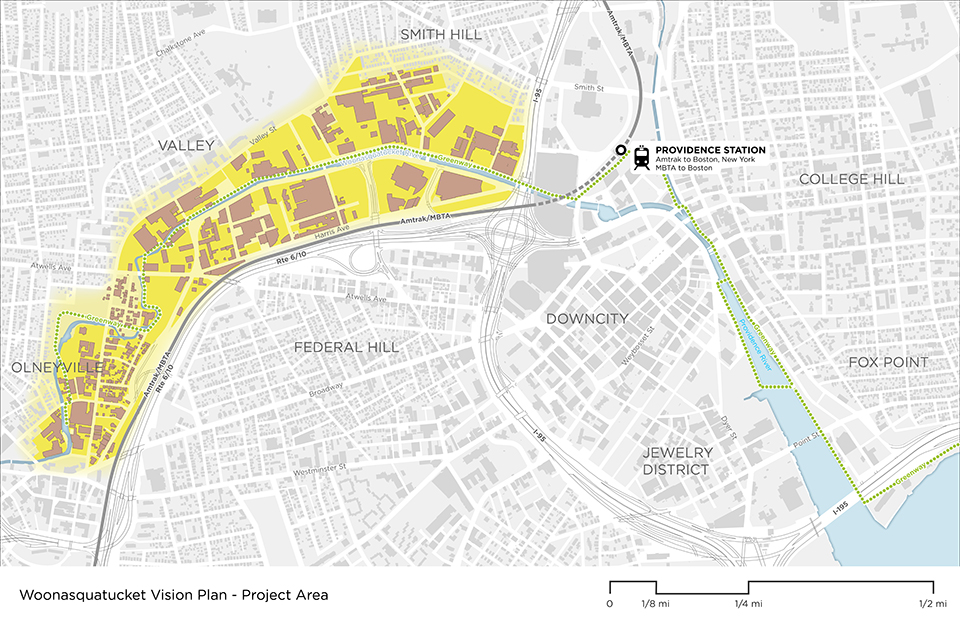
About the Woonasquatucket Vision Plan
The City of Providence, in partnership with the community, is proud to present the Woonasquatucket Vision Plan– a vision for the area along the Woonasquatucket River from Paragon Mills to Providence Place Mall– including portions of the City’s Olneyville, Valley, and Smith Hill neighborhoods. Funded by an Area-wide Planning Grant from the US Environmental Protection Agency, the City of Providence worked closely with community members to plan for the thoughtful redevelopment of polluted industrial sites to stimulate economic development that benefits Providence residents and strengthens environmental and social resilience in the Project Area. The Vision Plan will be used to guide the many investments planned and underway in the Project Area, determine other needed investments, and advocate and secure resources for implementation of the community’s vision.
View or download the full Woonasquatucket Vision Plan (July 2018):
Woonasquatucket River Watershed Flood Protection Project Watershed Plan – Environmental Document
The proposed Woonasquatucket River Watershed Flood Protection Project Watershed Plan – Environmental Document is a joint effort between the USDA – Natural Resource Conservation Service (NRCS), the Town of Smithfield, and the City of Providence to address repeated flooding that causes damages to residential and commercial development and presents a public safety risk during intense rainfall. This project will look at natural and social resource concerns and use engineering analyses to develop alternatives that may be constructed to reduce these flood concerns.
A virtual public meeting regarding this project will be held on Thursday, June 10, 2021 from 6pm to 7pm via Zoom. Check back on this site for a Zoom meeting link.
Meeting Notices: English | Spanish
Contact Us
Jess Lance, AICP
Principal Planner
401-680-8519
jlance@providenceri.gov
Facebook: @ProvPlanning
Twitter: @ProvPlanning


